NSW Government Low and Mid-Rise Housing Policy
Stage 2 of the NSW Government Low and Mid-Rise Housing Policy commenced on 28 February 2025, changing planning controls within 800 metres walking distance around 171 town centres and stations across Greater Sydney, the Central Coast, Illawarra-Shoalhaven and Hunter regions.
In Mosman, the new controls will apply to land zoned R2 Low Density Residential and R3 Medium Density Residential within 800 metres walking distance of:
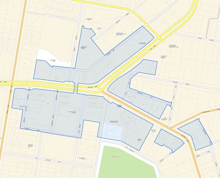
- Spit Junction
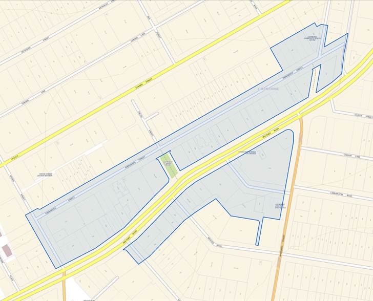
- Cremorne
The new controls will override Council’s planning controls and allow higher and denser development than is currently permitted.
Certain land is excluded from the Low and Mid-Rise Housing Policy, relevant to Mosman this includes:
- bushfire-prone land
- coastal wetlands, littoral rainforest or a coastal vulnerability area
- heritage items.
The Low and Mid-Rise Housing Policy does not apply to Employment zones or land zoned C4 Environmental Living.
Council continues to raise the following concerns about the Stage 2 reforms:
- Council should be allowed to accommodate the State’s housing targets in areas of Mosman Council’s choosing rather that this one-size-fits-all approach which has no regard to the individual circumstances of Mosman.
- The new controls will irrevocably alter the character of place established under Mosman Local Environmental Plan 2012 and will represent a transformative change to Mosman’s urban environment and will result in substantially larger built forms, dwelling yield and future population than Council and the community had anticipated. This is exacerbated in heritage conservation areas, which are not excluded from the changes.
- The reforms affect Council’s ability to ensure our communities will remain sustainable in the future with sufficient tree canopy to combat climate change and the urban heat island effect with substantially less landscaping than what is currently required for new medium density development under Mosman Local Environmental Plan 2012.
- DPHI has not released modelling at a State or individual council level to gauge the impact of these reforms, it is therefore unclear what the likely uptake of these reforms might be in Mosman. There has been no analysis about the impacts of the changes on things like traffic, parking, and community facilities, which are vital for our communities.
- The additional residential yields enabled under the Low and Mid-Rise Housing Policy will have longer term implications in terms of placing significant additional demand on infrastructure and services. The State Government has provided no additional investment in infrastructure to support the uplift.
Council staff are working through the details of the reforms and will provide more updates in the coming weeks as more detailed information is made available by the State Government.
Council hosted Community Information Sessions on the recently-announced Low and Mid-Rise Housing Policy at Allan Border Oval Pavilion on Wednesday 9 April, and online on Tuesday 15 April, for interested residents to learn more about the NSW Government’s recently-announced Low and Mid-Rise Housing Policy.
View the session recording and presentation slides.
Disclaimer: Please note that the information provided within these FAQs is our interpretation of the Low and Mid-Rise Housing Policy at a point in time and our views may change subject to emerging case law and as more detailed information is made available by the State Government.
What areas of Mosman are affected by the Low and Mid-Rise Housing Policy?
| Spit Junction Town Centre | Cremorne Town Centre |
|---|---|
 |
 |
How can I find out if my property is within the low and mid-rise housing area?
Landowners will not be notified if their site is within the low and mid-rise housing area.
The NSW Government has created an indicative map to help people understand what areas the policy may apply to.
The indicative map does not factor in individual property constraints, and local walking networks. Landowners will need to check the requirements in the legislation or engage a professional such as a town planner or architect to understand if a site is within the low and mid-rise housing area.
How do I access the indicative map?
Are there any exclusions?
What are the new rules within the low and mid-rise housing areas?
Multi-dwelling housing (townhouses, terraces, and manor houses) is now permitted in the R2 Low Density Residential zone within 800m of the nominated town centres. Dual occupancy is now permitted state-wide in the R2 Low Density Residential zone. This will be a significant change for these areas as these forms of development are not permitted in the R2 zone under Council’s rules.
New controls override Council’s local environmental plan and development control plan planning controls and allow higher and denser development than is currently allowed under Council’s rules.
A summary of the new planning controls is provided below:
Dual occupancies
Two dwellings
on one lot of
land, attached
or detached
Stage 1 permitted dual occupancy State-wide in the R2 zone.
Non-refusal standards within housing area in the R2 & R3 zone:
- Lot size: min 450m²
- Lot width: min 12m
- FSR: max 0.65:1
- Height: max 9.5m
- Car parking: 1 space / dwelling
- Subdivision: min 225m² / 6m width per lot
Council’s LEP and DCP controls apply outside housing area.
Multi-dwelling housing (terraces)
Three or more dwellings:
The dwellings are located side by side, with no part of a dwelling located above another dwelling.
Permits this form of development in the R2 zone for the first time within the housing area only.
Non-refusal standards within housing area in the R2 & R3 zone:
- Lot size: min 500m²
- Lot width: min 18m
- FSR: max 0.7:1
- Height: max 9.5m
- Car parking: 0.5 space / dwelling
- Subdivision: min 165m2 / 6m width per lot
Multi-dwelling housing
Three or more dwellings (whether attached or detached) on one lot of land, each with access at ground level, but does not include a residential flat building
Permits this form of development in the R2 zone for the first time within the housing area only.
Non-refusal standards within housing area in the R2 & R3 zone:
- Lot size: min 600m²
- Lot width: min 12m
- FSR: max 0.7:1
- Height: max 9.5m
- Car parking: 1 space / dwelling
| Residential flat buildings and shop-top housing | R2 Zone | R3 Zone 0 - 400m |
R3 Zone 400m – 800m |
|---|---|---|---|
| Height | 9.5m | 22m – residential flat building 24m - shop top housing |
17.5m |
| Storeys | N/A | 6 storeys or fewer | 4 storeys or fewer |
| FSR | 0.8:1 | 2.2:1 | 1.5:1 |
| Min frontage | 12m | Nil | Nil |
| Min lot size | 500m² | Nil | Nil |
It is recommended that you refer to Chapter 6 of State Environmental Planning Policy (Housing) 2021 to view the low and mid-rise planning controls.
How does Council consider site amalgamation?
How will Council assess impacts on heritage?
Land that contains a heritage item is exempt from the Low and Mid-Rise Housing Policy.
Each application involving heritage impacts will be considered on a case by case basis. The existing heritage provisions contained in the local environmental plan and development control plan will continue to be considered in the assessment of development applications. Any development adjoining heritage items or within heritage conservation areas must have a design sympathetic to the heritage significance.
Council will not consider removing heritage classifications on properties in order to be included in the policy.
How will Council consider walking distance?
Council has received many queries in terms of how to calculate walking distance. The term walking distance is defined within State Environmental Planning Policy (Housing) 2021 as follows:
The shortest distance between 2 points measured along a route that may be safely walked by a pedestrian using, as far as reasonably practicable, public footpaths and pedestrian crossings
Walking distance is measured from the nearest edge of the mapped town centre along a publicly accessible walking route. A key phrase within the walking distance definition is safely walked. For busy roads such as Spit Road, the walking distance route must be shown crossing at traffic lights or a designated crossing and the route must follow the NSW Road Rules.
The applicant will need to demonstrate how their land meets the walking distance requirement as part of the development application. As part of the development application assessment, Council will look at proposed walking distance routes very closely and will be guided by emerging case law in terms of what is appropriate. For some sites particularly those near the edge of the 400m/800m, it will be necessary for a surveyor to precisely calculate walking distances.
What are non-discretionary development standards and can buildings be built higher than that detailed in the Mosman LEP?
Non-discretionary development standards, also known as non-refusal standards provide consistent development standards for matters like building height, floor space ratio and lot size.
The non-discretionary standards in the Low and Mid-Rise Housing Policy apply when they are more generous than those in the local environmental plan (LEP) or development control plan (DCP). For instance, where the State Environmental Planning Policy (Housing) 2021 permits a taller building than the LEP, the Housing SEPP building height would apply. That is these controls override Mosman Council controls.
If the proposed development complies with the non-discretionary standard, a consent authority cannot refuse the application because it does not meet the equivalent LEP or DCP standard.
All other applicable planning controls, such as in state environmental planning policies (SEPPs), LEP and DCPs continue to apply and operate as normal.
I am just outside the low and mid-rise housing area – can I be included or can the map be extended?
I am not within the low and mid-rise housing area but the street adjacent to me is – any new proposal will block my views and impact my property – will Council refuse a DA based on this?
Each development application has to be assessed on its merits. However as mentioned above. The non-discretionary standards in the Low and Mid-Rise Housing Policy apply when they are more generous than those in the local environmental plan (LEP) or development control plan (DCP). For instance, where the State Environmental Planning Policy (Housing) 2021 permits a taller building than the LEP, the Housing SEPP building height would apply. That is - these controls override Mosman Council controls.
Views and other impacts on neighbour’s properties that previously may not have been acceptable under Mosman specific controls are acceptable under these new State Government controls.
What can I build on my property?
- by emailing council@mosman.nsw.gov.au
- by phoning the planning advisor number 9978 4214
- book an appointment to meet with Council's Planning Advisor
Further information, maps and FAQs are available on the NSW Planning website.